
Geodetic
The software was first developed in 1984 to run on a PC running under DOS and has been constantly been redeveloped in line with PC development.
The current version runs under Windows XP and Vista.
Based on the computational routines used with Geodetic Norcom has developed a stand alone DLL that can be incorporated into and third party software developed
in Visual Basic or Visual C++ For more details
Grid to Geographical
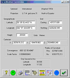 Also computed:-
-
Cartesian Co-ordinates (X,Y,Z)
-
Convergence
-
Point Scale Factor
-
Radii of Curvature (Rho, Nu)
-
One Second of Arc
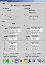
Datum Shift
Methods Include
-
3 / 5 / 7 Parameter Shift
-
NADCON (North American Datum)
-
Statens KartVerk Norway.
-
Geographical Shifts
-
Grid Translations
-
OSGB
Bulk Transfer
Co-ordinate conversion of data from an ACSII file.
Features include:-![]()
-
User defined data input
- User defined data output
- Grid to Geog conversion
- Datum Shift co-ordinates.
- User defined units.
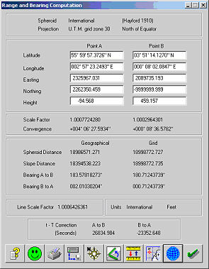
Range and Bearing Calculation
-
Range and bearing between two point
-
Spheroid and Slope Distance
-
Forward and Reverse Bearing
-
Line Scale Factor
-
t-T Correction for TM Projection
Long Line Calculation
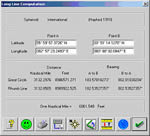 Great Circle Range and Bearing
 -
Rhumb Line Range and Bearing
-
Length of One Nautical Mile
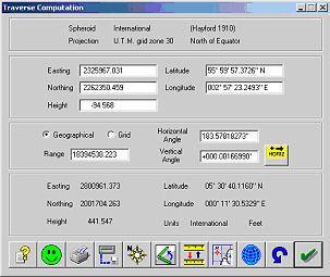
Traverse Calculation
-
Computation from range & bearing.
-
Grid or Geographical Computation
-
Height computed from Vertical Angle
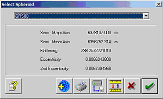
Spheroids
35 pre-defined spheroids including:-
-
GRS80
-
WGS84
- Hayford International.
-
Clarke
-
Bessel
-
Everest
- Semi-Major Axis (a)
- Semi-Minor Axis (b)
- Inverse Flattening (f)
- Eccentricity (e)
Projections
Projections types include:-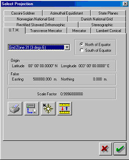
-
Transverse Mercator
- Mercator
- Lambert Conical
- Cassini-Soldner
- Azimuthal Equidistant
- State Plane (USA)
- Rectified Skew Orthomorphic (Borneo and Malaysia),
- Norwegian National Grid (NGO)
- Danish National Grid
- Stereographic.
Including over 150 pre-defined projection parameters.
Datums
Predefined datum shift parameters including:-
-
WGS84 to OSGB36
-
NADCON (North American Datum)
-
Statens KartVerk Norway.
Plus user entered data of:-
-
Transformations (dX, dY, dZ)
-
Rotations (rX, rY, rZ)
-
Scale Factor (ppm)
- Co-ordinate Frame
- Position Vector
Unit Format
Geographicals and Angles
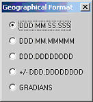 Degrees, Minutes and Seconds
-
Degrees and Minutes
-
Degrees
-
Gradians
Default Geographical Quadrants
-
Latitude (North or South)
-
Longitude (East or West)
Units of Length
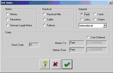 Metric
- Nautical
- Imperial
- User Defined
Date
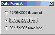 Day, Month and Year all Numeric
- Month as Text
- American Format Month, Day and Year
Time
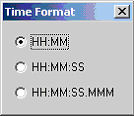 Hours and Minutes
-
Hours, Minutes and Seconds
-
Hours, Minutes, Seconds and Milliseconds
 You can keep up to date on all the latest special offers, events and more via any of the following networking sites.