
Ptolemy
 PC based online navigation and positioning software for Hydrographic survey work.
Propriety techniques are used to acquire, compute, display and log data from multiple survey.
-
Multiple display windows either vector or raster data.
-
All data clearly identified with own colour, all colours can be user defined.
-
Each window can be individually scaled. Vector displayed can be displayed
at any rotation. -
Ability to overlay real time information including multiple vessel positions
acquired via GPS unit, over telemetry, AIS systems or from vessel’s radar. -
Each vessel clearly identified by name and or colour.
-
Heading from the USBL system, Gyro or manually entered.
-
Up to 16 USBL beacons can be monitored simultaneously.
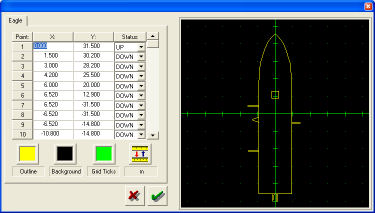
The application allows the ability to enter the following information
-
Outline of the vessel
-
Antenna offset from the common reference point (CRP).
-
Offsets from the CRP to any point including echo sounder and USBL transducer.
-
Corrections to Gyro USBL and Echo sounder
Alphanumeric Display
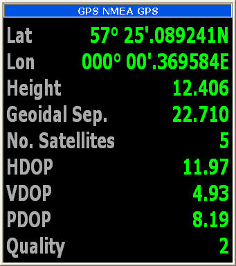 All data can be displayed in Alpha Numeric Displays that can be configured by the used.
Prejob Planning
-
Importing of coastline and other vector data from AutoCAD DXF files.
-
Data entry of guidance data including Sail Lines, Pipelines, Cable routes, Markers,
Symbols and exclusion zones.
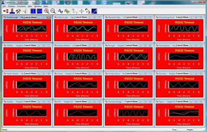
Data Logging
The logging section of the Ptolemy software enables logging of data from devices via a
multi port RS232 card
-
The application provides the ability to monitor incoming data.
-
All sensor data is logged as ASCII data.
-
Data files automatically named based on date and time.
-
The size of data files is user selectable
 You can keep up to date on all the latest special offers, events and more via any of the following networking sites.